
EO4SD forest management
This product supports the quantification of Biomass Change, which can be used to identify degradation and forest loss for REDD+ and other forest monitoring purposes.
By combining a biomass map with a dynamic forest change map, rather than a static forest area map, it is possible to understand the change in biomass over time. Biomass maps can be used to derive emission factor (EF) information resulting from changes in land use (where land use/ land cover information is available) and can be used in reporting for a number of mechanisms. Areas of high carbon stock, and potential emission hotspots (if deforestation were to occur) can also be identified.
The Biomass product can be used as an input for:
- Assessment of Activity Data for REDD+
- Sustainable Forest Management (SFM)
- Forest Landscape Restoration (FLR)
- Forest management/ planning
- Mangrove Monitoring
PRODUCT SPECIFICATIONS
CONTENT
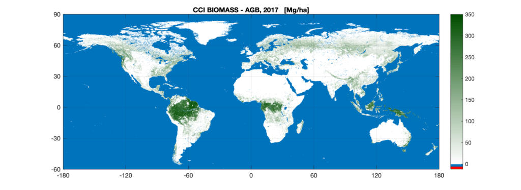
A global terrestrial biomass map of 100 m resolution was produced for 2010, 2017 and 2018.
The maps were produced by the ESA’s Climate Change Initiative Biomass Project (more info)
GEOGRAPHICAL COVERAGE
Global, Regional, National, Sub-national
Wall-to-wall global products available for several time periods
TEMPORAL COVERAGE & FREQUENCY
Three time periods are currently available: 2010, 2017, and 2018.
EO DATA AND SPATIAL RESOLUTION
Sentinel-1 and ALOS-2 PALSAR-2 data (inputs),
SCANSAR data, ICESAT data and Moderate Resolution Imaging Spectroradiometer (MODIS) Vegetation Continuous Fields (VCF; or MOD444B for map production
Spatial resolution: 100m
ACCURACY
Global AGB map tends to over-estimate biomass at low biomass ranges (50-100 Mg ha-1) and under-estimate at high biomass ranges (> 250 Mg Ha-1)
Between 50 and 300 Mg ha-1, mean differences between the map and reference dataset are well within 20% of the map values.
Per pixel error values expressed as standard error are provided.
Positional accuracy needs to be validated at a national level.
PRODUCT DELIVERY
Available Formats
- OGC compliant service (e.g. WMS, WFS)
- Geodata in NetCDF-4, GeoTIFF, ASCII or similar, accompanied with metadata (INSPIRE or ISO)
- Cartographic products in .pdf, .png or similar
Dta Access Options
- USB, hard drive
- Download from dedicated password-protected ftp server or cloud platform
- Viewed online through password-protected web portal (Open Geospatial Consortium (OGC) compliant. The web portal can be customised to include various online analysis options, time series plots, statistical plots and to integrate user-defined datasets
Support Available
- Quality Management Systems cover non-conformance issues, timely corrective actions and supporting services relating to reliability, flexibility and timely delivery of services. All quality relevant information and quality checks are documented and cover:
- Compliance of output with user requirements,
- Completeness
- Thematic accuracy
- Thematic completeness
- Positional accuracy
- Product utility
Tailored training can be provided on product use and integration for further geospatial analysis